
The CRC project ‘Supporting agricultural business development in Namoi’ pairs Dr Hoon Han, an Associate Professor within University of New South Wales (UNSW) Sydney’s School of Built Environment, with Namoi Unlimited – five Northern Rivers-area councils keen to boost agribusiness development in this rich agricultural region.
The aim of the year-long project, which commenced in early 2022, is to develop a web-based multi-criteria decision support tool that Namoi-group council planners and economic development officers can use to guide decisions about land use, as an aid to sustainable agribusiness development and investment attraction.
To develop the tool, the project team first needs to select “adequate and relevant” criteria by which land suitability can be determined, says Dr Han. Then, it needs to collect data based on those criteria. Finally, the team will use that data to create an open-source, geographic information system (GIS)-based multi-criterion analysis (MCA) tool that council planners can use to identify the most suitable locations for specific agribusinesses.

Reviewing the literature
The project team’s first step was to conduct a comprehensive literature review to inform their selection of criteria for land suitability, Dr Han says.
The team found that some common criteria used in livestock and farming suitability works include climatic, soil, and topographic characteristics (Herzberg et al., 2019; Maleki et al., 2017; Ostovari et al., 2019).
Land zoning and use, and proximity to nature conservation/reserves, transport routes, surface water, residential areas and existing large-scale livestock farms are other notable criteria (Qiu et al., 2017).
Factors such as land elevation and vegetation may also be important in determining whether an area is suitable for farming: low-lying areas could be prone to flooding; heavily vegetated land could mean an increased risk of bushfires.
“It’s not simply mapping the data,” notes Dr Han. “Different variables are important to different types of business.
“For a chicken farmer, a good water supply might be the key factor; for a food manufacturing business, access to electricity is more important.”
To agribusinesses such as livestock producers or dairy farmers, proximity to transport routes connecting farms with abattoirs, dairy processors, saleyards and end markets will be critical.
Acquiring key data
The quality of its decision support tool is dependent on the quality of the data, Dr Han notes. And for this, collaboration with the Namoi group of councils is key.
“As collecting data from scratch is very time-consuming, and we don’t have the time or resources to do this, we’ve been relying on Namoi Unlimited to help us access what data does exist,” says Dr Han.
Already, Dr Han is in frequent contact with Namoi Unlimited’s Executive Officer Rebel Thomson, with whom he and his research assistant (a PhD within UNSW’s School of Built Environment) have fortnightly meetings to discuss project progress and data requirements.
In turn, Thomson liaises between the project team and Namoi Unlimited’s Board, which includes the Mayors of all five member Councils – the Gunnedah, Gwydir and Liverpool Plains Shire Councils, Tamworth Regional Council and Walcha Council.
They in turn can consult with key stakeholders in the region, including local farmers and food processing and manufacturing businesses, to ensure the team has as much useful data as possible.
“Around 20 per cent of the data we would like to have – such as who owns what available land – is just not available,” says Dr Han. “But with Rebel’s help, we have access to the most up-to-date data on electricity and water supply, road infrastructure, zonings, and the locations of many of the existing agribusinesses in the region.”
The team can obtain supporting data, such as population statistics, and transport, weather and topographical maps, through bodies such as the Australian Bureau of Statistics, Local Land Services, the NSW Department of Transport and the Bureau of Meteorology, Dr Han notes. The suitability criteria selection step will be further improved in consultation with NSW Department of Primary Industries guidelines (DPI, 2022).
The decision support tool the project team develops will also take into account statutory rules currently being established for new intensive animal protein precincts by the NSW Government Namoi Job Precinct initiative.
“Ultimately, the maps we produce can only be as good as the data they’re based on,” Dr Han admits, “but we can get 80 per cent of what we need, and we’ll work with what we’ve got.”
Developing the tool
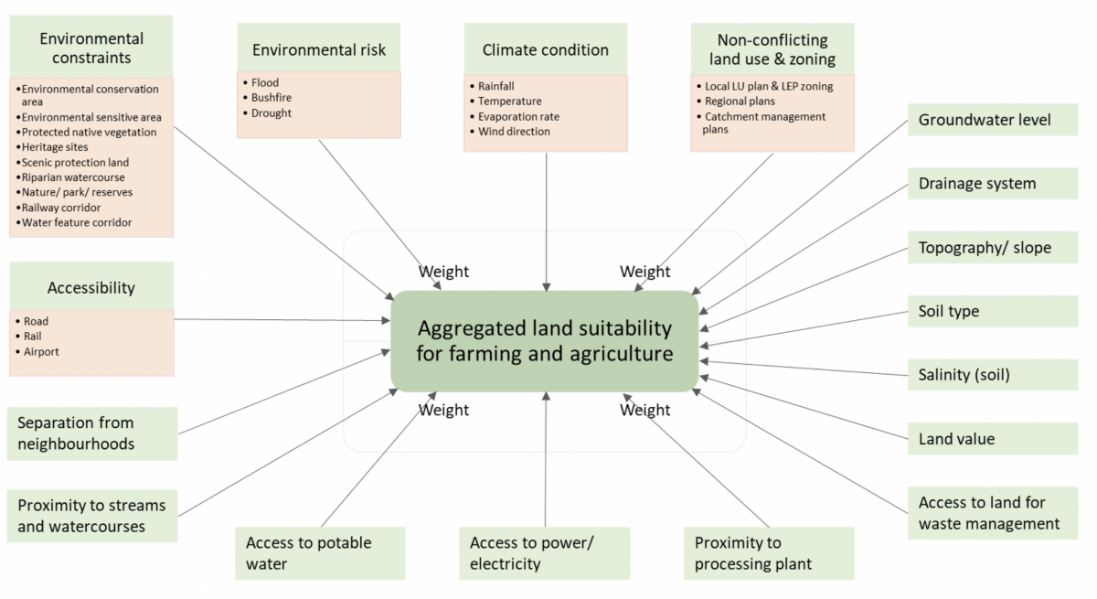
The next challenge for the project team is to turn all that data into a web-based multi-criteria decision support tool using what is known as multi-criteria analysis (MCA).
“A multi-criteria analysis is a decision-making framework for ranking options suited to solving problems with multiple alternative courses of action,” Dr Han explains. “Combined with Geographic Information Systems (GIS), MCA helps determine one option against multiple possibilities in planning decision-making problems.”
In particular, land suitability analysis using GIS-based MCA methods has reportedly been critical for its sustainable use and management, in the cases of both agricultural (Maleki et al., 2017; Ostovari et al., 2019; Yohannes & Soromessa, 2018) and livestock rearing (Qiu et al., 2017) purposes.
The suitability analysis process follows some basic steps consisting of criteria selection, standardisation, weight determination and aggregation (Qiu et al., 2017).
Subsequently, the standardisation of each criterion can be grouped into four classes: namely, ‘very suitable’, ‘moderately suitable’, ‘marginally suitable’ and ‘unsuitable’.
Determining the weight of each criterion can be based either on evidence from the literature survey, or on expert opinion.
When determining weights with expert stakeholders, the Analytic Hierarchy Process (AHP) is a common alternative (Ostovari et al., 2019; Qiu et al., 2017). It involves pairwise comparisons of the selected criteria.
The MCAS-S tool the team plans to use has a built-in AHP module to support this work.
Finally, a weighted linear combination method may be applied as an aggregation method to generate the suitability output given that the criteria are standardised to a common numeric range (Qiu et al., 2017).
The following MCA model for agricultural land suitability provides an overview of the planned MCA process for the Namoi project.
Once developed, the web-based multi-criteria decision support tool can be used by Namoi council planning and economic development officers to advise on optimal locations for new infrastructure and agrifood businesses, supporting regional industry growth and investment attraction.
Tying in to Namoi Unlimited’s strategy for regional development
Extensive social and economic research conducted by Namoi Unlimited in 2015 yielded six Strategic Regional Priorities to deliver growth for the region:
- understanding national and global cycles of commodity markets;
- maximising innovation in agricultural production;
- seeking international investment, on the right terms;
- engaging the Namoi in major overseas markets;
- understanding urbanisation; and
- leveraging regional and brand marketing to attract people to live and work in the region.
The ‘Smart regional planning in the Namoi’ project will lay the groundwork for delivering on a number of these Priorities.
More about Dr Hoon Han
Dr Hoon Han is Associate Professor of City Planning Program in the School of Built Environment, part of UNSW Sydney. Prior to joining UNSW in January 2011, he held teaching and researcher positions at Griffith University (2009-2011) and the University of Queensland (2004-2009), where he completed his PhD in 2004. Dr Han’s research focus is on spatially integrated social science, using a range of quantitative tools.
More about Namoi Unlimited
Namoi Unlimited is a Joint Organisation (JO) of Councils in New South Wales. A JO is a voluntary function of Councils that enables them to collaborate, plan, set priorities and deliver important projects in regional NSW.
References
ABARES. (2022). MCAS-S tool. Retrieved from https://www.awe.gov.au/abares/aclump/multi-criteria-analysis/mcas-s-tool
DPI. (2022). Animals & livestock. Retrieved from https://www.dpi.nsw.gov.au/animals-and-livestock
Herzberg, R., Pham, T. G., Kappas, M., Wyss, D., & Tran, C. T. (2019). Multi-Criteria Decision Analysis for the Land Evaluation of Potential Agricultural Land Use Types in a Hilly Area of Central Vietnam. Land, 8(6). doi:10.3390/land8060090
Maleki, F., Kazemi, H., Siahmarguee, A., & Kamkar, B. (2017). Development of a land use suitability model for saffron (Crocus sativus L.) cultivation by multi-criteria evaluation and spatial analysis. Ecological Engineering, 106, 140-153. doi:https://doi.org/10.1016/j.ecoleng.2017.05.050
Ostovari, Y., Honarbakhsh, A., Sangoony, H., Zolfaghari, F., Maleki, K., & Ingram, B. (2019). GIS and multi-criteria decision-making analysis assessment of land suitability for rapeseed farming in calcareous soils of semi-arid regions. Ecological Indicators, 103, 479-487. doi:https://doi.org/10.1016/j.ecolind.2019.04.051
Qiu, L., Zhu, J., Pan, Y., Hu, W., & Amable, G. S. (2017). Multi-criteria land use suitability analysis for livestock development planning in Hangzhou metropolitan area, China. Journal of Cleaner Production, 161, 1011-1019. doi:https://doi.org/10.1016/j.jclepro.2017.07.053
Ramanathan, R. (2004). Multicriteria Analysis of Energy. In C. J. Cleveland (Ed.), Encyclopedia of Energy (pp. 77-88). New York: Elsevier.
Yohannes, H., & Soromessa, T. (2018). Land suitability assessment for major crops by using GIS-based multi-criteria approach in Andit Tid watershed, Ethiopia. Cogent Food & Agriculture, 4(1), 1470481. doi:10.1080/23311932.2018.1470481
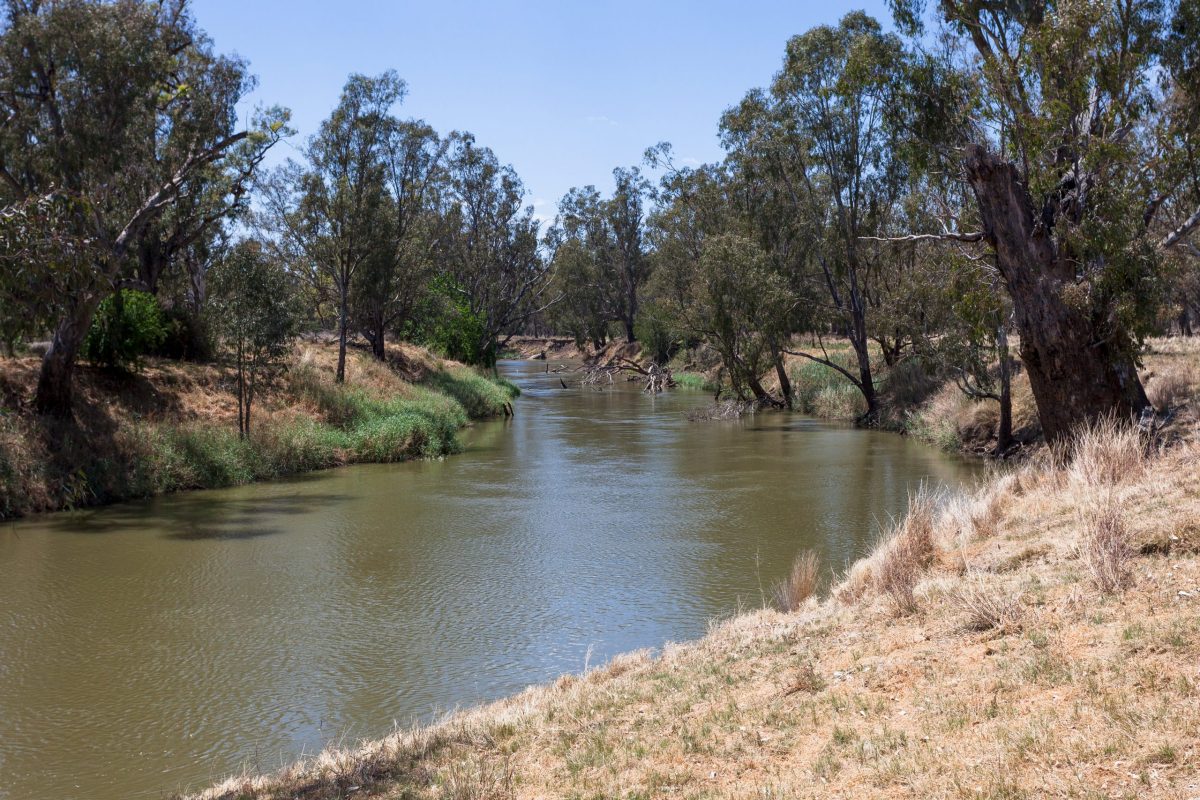
Lead image: The Namoi River, which runs through this rich agricultural region in NSW’s north-west. Credit: Shutterstock